Florida State Parks
Florida Department of Environmental Protection

Main Menu

  • Plan your visit
    • Access for All
    • FAQs
    • Fees
    • Rules & Regulations
    • Camping & Lodging
  • Find a Park
  • Learn
  • Resources
  • Experiences & Amenities
    • Educational Opportunities
    • Programs
    • Research & Collecting
  • Get Involved
  • Events
  • Search
  • Camping & Lodging
  • Shop

Breadcrumb

  1. Home
  2. Find a Park
Boat Lanch Area

Inglis Dam & Island Recreation Area

Trails and History make this a unique spot

Hours

 8 a.m. until sundown, 365 days a year

Fees

No fee required

Location

10905 W. Riverwood Drive
Crystal River FL 34428

Get directions

Contact Info

352-758-1000

Park Menu

  • Cross Florida Greenway
  • Experiences & Amenities

Welcome to Inglis Dam & Island Recreation Area

Lake Rousseau was originally flooded in the early 1900s with a hydro-electric dam.

The dam was constructed to provide electricity to power the phosphate mining boom that occurred in the Dunnellon area at the turn of the century.

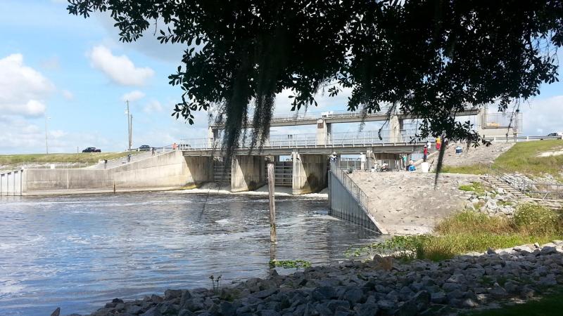
The Inglis Dam Recreation Area is located off West Riverwood Drive approximately 2 miles east of U.S. 19. The Inglis Main Dam, the larger of two spillway structures for Lake Rousseau, is located at this site and provides an access bridge onto Inglis Island’s south side.

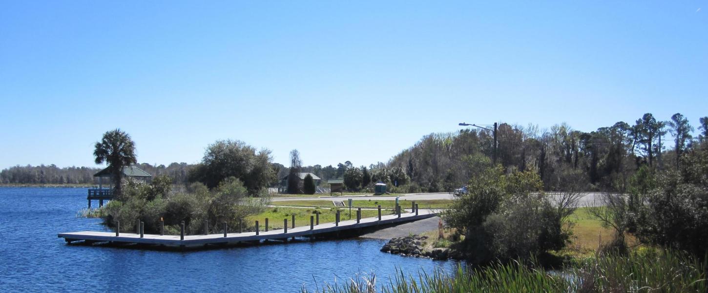
Ample paved parking is located south of the Main Dam along with a boat ramp to access the upstream Lake Rousseau side of the dam. If boating in Lake Rousseau, it is wise to stay within the marked navigation channels. The river channel maintained by Cross Florida Greenway staff and side channels maintained by Citrus County along the south side of the lake are the only parts of Rousseau that are not heavily riddled with stumps. Multi-use platforms run along the lakeshore for freshwater fishing, bird-watching or picnicking.

On the lower downstream side of the dam is another large paved parking area with another boat ramp that also serves as a canoe/kayak launch. This ramp provides access to the Withlacoochee River segment that runs 1.5 miles from below the Main Dam and Spillway to the barge canal channel. This segment of the old river can have high freshwater flows if significant discharges from the lake are needed, but often there is little or no flow and the river can be tidally influenced from the Gulf of America.

There is both fresh and saltwater fish species to catch on the downstream side of the dam, and occasionally manatees are seen in these waters during the warmer months.

Plan Your Visit

Rodman Dam
Learn

Manager's Message

With more than 70,000-plus acres and 290 miles of trails for bikers, hikers and equestrians, there is plenty to explore. And for water lovers, there are many paddling opportunities along the Ocklawaha and Withlacoochee rivers.
A young woman holds a red drum fish on the beach.
Learn

Great Parks for Fishing

Florida fishing is heating up! We created this list of top fishing spots for saltwater and freshwater anglers.

Experiences

Bicycling
Bicycling
Birding
Birding
Boating
Boating
Fishing
Fishing
Geo-Seeking
Geo-Seeking
Hiking
Hiking
Horseback Riding
Horseback Riding
Mountain Biking
Mountain Biking
Picnicking
Picnicking
Roller Blading
Roller Blading
Walking and Running
Walking and Running
Wildlife Viewing
Wildlife Viewing

Amenities

Accessible Amenities
Boat Ramp
Boat Ramp
Equestrian Trail
Equestrian Trail
Parking
Parking
Pets
Pets
Picnic Pavilion
Picnic Pavilion
Wheelchair Accessible
1967 Holiday Inn sign welcoming the Cross-Florida Barge Canal. Black and white image.
Learn

History of the Cross Florida Greenway

The greenway follows the path of the abandoned Cross-Florida Barge Canal. Despite never being completed, the gargantuan public works project has a long history.
4 mountain bike riders on their bikes at the vortex
Learn

Biking at the Cross Florida Greenway

Explore your adventurous side on the Vortex biking ramp or simply traverse the miles of trails at at Cross Florida Greenway. There are over 80 miles of mountain bike trails and a recently added 16 miles of paved trail for road bikers to enjoy. Our system offers trails for all levels of experience. 

Park Map

More Places You Might Like

See all parks
Faver-Dykes State Park

Faver-Dykes State Park

It's a great day to visit the park and relax along Pellicer Creek, take a walk on the nature trail, enjoy a picnic or stay in the campground. Faver-Dykes is conveniently located on the outskirts of St. Augustine.

1000 Faver-Dykes Road
St. Augustine FL 32086

A man rides a bicycle at Felburn Park on the Marjorie Harris Carr Cross Florida Greenway.

Felburn Park

Located just east of U.S. 19 on the south side of the Cross Florida Barge Canal, Felburn Park has paved parking, potable water, several picnic pavilions, a small playground and access to paved trails along the barge canal.

10201 N. Suncoast Blvd.
Crystal River FL 34428

Front of Main Visitors Center at De Leon Sorings

De Leon Springs State Park

De Leon Springs State Park offers visitors a Florida experience that includes a recreational swimming area and a fascinating history. Take a walk through this majestic park before enjoying the crystal springs.

601 Ponce De Leon Blvd.
De Leon Springs FL 32130

Florida State Parks

Main Menu

  • Plan your visit
    • Access for All
    • FAQs
    • Fees
    • Rules & Regulations
    • Camping & Lodging
  • Find a Park
  • Learn
  • Resources
  • Experiences & Amenities
    • Educational Opportunities
    • Programs
    • Research & Collecting
  • Get Involved
  • Events

Have Questions?

Contact the Statewide Information Line:

(850) 245-2157

Or send an email to:

FSP.Feedback@FloridaDEP.gov

Stay Connected

  • Facebook
  • Twitter
  • Instagram
  • Pinterest
  • You Tube
© Copyright 2025 © Copyright 2018 Florida Department of Environmental Protection.
  • Customer Survey
  • Disclaimer
  • Privacy Policy
  • Website Login